Showing posts with label archaeology. Show all posts

Wednesday, April 6, 2016

"Vikings Unearthed" in Iceland

One of the joys of writing my book The Far Traveler was joining an archaeological crew in northern Iceland for six weeks in 2005. There I worked with Doug Bolender, who is featured on the NOVA TV program "Vikings Unearthed" airing tonight (April 6, 2016) on PBS.

The summer I joined them, Doug and his colleague John Steinberg, both now at the University of Massachusetts-Boston, were testing a new protocol that has since proved to be a very powerful way to locate ancient structures buried beneath the soil--without having to dig. Their method centered on a ground-penetrating radar (GPR) device: a sealed plastic box full of electronics, which sent pulses of microwaves into the ground and picked up their echoes; these were then read by sophisticated computer algorithms and compiled into detailed maps of the density and other characteristics of the earth at certain depths. The archaeologists spent weeks dragging the GPR box over the ground above a suspected Viking Age house. My contribution was to hold one end of a 100-meter tape measure so they would walk in a straight line.

John Steinberg and team doing GPR in Iceland in 2005.
Paired with this high-tech gadget was a more primitive tool: a soil-corer, a steel T made of tubing, with a narrow opening the length of the shaft. But the method, as I learned one day, was just as precise and equally tedious.

Following a mental grid Doug had set over the field using GPS, we took a sample every 50 meters (165 feet) along a certain north-south line, then turned east and took another line. For each core, we chose a place between þúfur—the knee-high grassy hummocks caused by frost-heaving. Þúfur is one of the first Icelandic words you learn out on the farms. They make walking through an Icelandic pasture an obstacle course, taxing the ankles and straining the knees. Once I misstepped, my attention caught by a pretty palomino stallion in the next field, and fell full-length on top of a þúfa—it was like a belly-flop onto a medicine ball.

While I floundered, Doug had found a grid-point between two thufur and plucked away the grass. Once I’d found my feet, he handed me the coring tube with a flourish. Attempting to regain my dignity as well, I punched it through the turf and pulled out and discarded the root-plug, as he had instructed. Then I pushed the instrument straight down, stomping on the foot pedal, which, like usual, slipped from its groove, leaving me stomping air and jarring my back. Doug laughed and took over: He had a special wiggle that made the pedal work.

Archaeologist Doug Bolender working in Iceland in 2015.
When the corer was fully buried, he stepped aside again to let me redeem myself. “Don’t twist it,” he warned. I crouched, set my feet well under the handle, hooked my elbows under the cross-bar, and lifted up with my thighs, not my (already tender) back. The tube slowly slid from the earth, full of soil. Doug sliced his pocketknife across the narrow opening to reveal the strata of that 50-centimeter (20-inch) sample: layers of deep red, black, shiny white, then brown, rust-red, tan, and honey-yellow. Some of the strata had been swirled around, either by flooding or by what Doug called “cryoturbation”: freeze-thawing, the same process that makes the þúfur, which inspired one member of the team to rename it thufurization.

The core was beautiful. “You could make upholstery out of that one,” Doug said.

A sample soil core from the SCASS blog.
I took up the clipboard to log in the color and depth of each soil layer and measure the location of the volcanic tephra lines. The honey-yellow line near the bottom of the core was tephra from an eruption of Mount Hekla nearly 3,000 years ago. It marked prehistoric soil, telling us we’d drilled deep enough. The shiny white tephra was more interesting: the distinctive marker left by Hekla’s eruption in 1104. In between there should have been—but I couldn’t see it—a thin dark gray layer. This tephra has been dated, by comparing its chemistry to dust found in the Greenland ice cores, to 871 (plus or minus two years). The date is remarkably close to when Iceland’s first historian, Ari the Learned, says Iceland was settled: 874. Archaeologists call this tephra the Landnám or Settlement Layer. Another, lighter greenish-gray tephra—also, unfortunately, not visible in this core—dates to the year 1000. Layers from 1300 and 1766, likewise conveniently color-coded, can also be found in Skagafjord cores.

Tephra line in a turf wall in Iceland.
The volcanoes from which this tephra spewed are clear across Iceland, near the south coast. The wind direction during the eruption, and the ground cover where the tephra landed, determined if a core will have a tephra line or not: bushes and thick grass trapped tephra, while on bare gravel and rock it washed away. Skagafjord is a good spot for archaeologists because the wind generally did bring tephra from these historically important eruptions north.

Using this handy vulcanological dating method, if you take enough soil samples (and for his Ph.D. dissertation on medieval farming practices, Doug collected approximately 16,000), you can see a “massive jump” in phosphorous levels, due to animal manure, in farmers’ fields between 870 and 1100. You can also, if your grid is tight enough, find and date the farmers’ houses and garbage middens by the position in the soil cores of charcoal, bone, peat ash, or chunks of turf.

It's not an easy job to get 16,000 soil cores. There are surprising dangers.

One day, two members of our team, Susan and Tara, were coring in a fenced field. The farmer had told them it contained a herd of “calves.” One came over and pissed on the leather corer bag. The next day, it came up to them and let them scratch its nose. It stood beside them, grazing, while they recorded the last soil core.

Skagafjörður, Iceland, where we were coring.
When they were ready to leave, they decided it wasn’t a good idea to get between him and the rest of the herd, so they walked directly away from the "calf." He snorted and champed and charged after them, suddenly morphed into a raging bull. They ran, dodging thufur, clutching their instruments.

Up ahead Tara saw a drainage ditch—This way!—she leaped into the ditch and sank up to her thighs in muck. Susan followed. The bull tried to get under the fence and into the ditch. He went under head and shoulders. They dropped the corers on the bank and slogged up the ditch away from him until they could get up the bank and under the far fence.  Leaping up the bank out of the ditch, Tara cradled the $300 GPS monitor, Susan the soil-coring data sheet. They waited until the bull lost interest and went away before going back into the ditch to retrieve the rest of their equipment.

Watch the PBS special "Vikings Unearthed" online here: http://www.pbs.org/wgbh/nova/ancient/vikings-unearthed.html. For more on my book The Far Traveler, see my website at: https://www.nasw.org/users/nmb/books.html#FT. For more on Doug Bolender's work at UMass-Boston, see the blog of the Skagafjörður Church and Settlement Survey here: http://blogs.umb.edu/scass/2016/04/02/doug-bolender-stars-on-vikings-unearthed/.

Wednesday, September 11, 2013

Surtshellir: The Outlaw's Cave


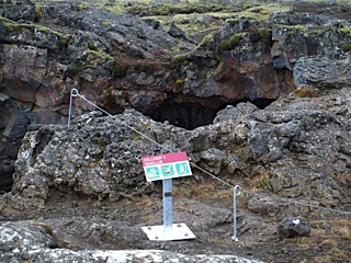
To explore the Outlaw's Cave, my friend told me, you need "a headlamp and serious shoes." I had a headlamp, though it malfunctioned and would only point straight down. On my feet I had rubber Wellington books--not up to clambering over hummocks of toaster-sized lava-rubble without twisting an ankle. I didn't make it far into the cave.

I never saw the statues a local artist had placed there--eerie faces carved of rock, I'd heard.

I missed the ice formations that apparently linger year round.

I gave up well before I reached the outlaws' hideout, thoroughly freaked out by being alone in the unimaginable dark, some 30 feet under a lava field on the fringe of Iceland's uninhabitable interior. If I cried for help, no one would hear.

Usually cavers don't come to Surtshellir alone. And most are more courageous than I. In fact, so many tourists have reached the outlaws' hideout, some 600 feet along this lava tube, that Icelandic archaeologists have launched a rescue excavation to learn what they can about the outlaws' house before the evidence disappears. As archaeologist Guðmundur Ólafsson  and his colleagues noted in 2004, tourists "were removing bones from it as souvenirs."

Surtshellir means "the cave of Surtr," the Norse fire-giant who will destroy the world. The lava in which the cave is found flowed shortly after Iceland was settled in the 870s. A mile-long tube, or tunnel, the cave was formed by thicker lava congealing around a faster flowing central stream that eventually ran out. At its broadest, the tube is about 45 feet wide and 30 feet high, though it shrinks down to about 6 feet high. In some places it branches out into side tunnels. In other places, the roof has fallen in, leaving large holes to the sky.

Beneath one of these sky holes, about 300 feet from the cave's mouth, the outlaws built a wall about 8 feet high and 43 feet long. Another 300 feet along a side passage stands "a unique drystone structure with an associated midden," or garbage dump, according to the archaeologists.

One of the first books written in Iceland, the Landnámabók or Book of Settlements (from about 1130) notes that outlaws lived in in the lava field near Surtshellir in the late 900s. Two of the Icelandic sagas (written in the 1200s and 1300s) describe the outlaws' downfall, when a posse of chieftains decided to wipe them out.

In the 1700s century, two Icelanders explored the cave and found what they thought was the outlaws' hut. Two centuries later, the Icelandic novelist Halldor Laxness visited the cave and had his souvenir cow-bone dated by radiocarbon (carbon-14) testing in 1971. The dates he got spanned Iceland's Golden Age, from its founding in 870 to when it became a colony of Norway in 1264.

Since 1971, radiocarbon dating has improved. In 2004, Guðmundur Ólafsson and his colleagues dated some cow-bones from the midden to between 690 and 960.

The science of tephrochronology is also new since Halldor Laxness's effort; it uses the Greenland ice cores and other sources of information to date the layers of volcanic ash, or tephra, found like stripes in Iceland's soil. The lava field around Surtshellir rests on top of a tephra layer from an eruption dated to 871 (plus or minus 2 years).

That means the earliest date for outlaws to have lived in the cave (and left cow-bones in their garbage) is about 880. A range of 880 to 960, Guðmundur Ólafsson notes, is roughly consistent with the stories in the Icelandic sagas.

Which is why Guðmundur is a little puzzled by what he and his colleagues found in the cave in 2013, according to a recent report from Iceland Review.

With Kevin Smith from Brown University and Agnes Stefánsdóttir of Iceland's Cultural Heritage Agency, Guðmundur had made a 3D scan of the Outlaw's Cave in 2012. This year, the team returned--with huge lights--to excavate the cave floor. "Because there's an increased flow of tourists to the cave, we considered it necessary to save these remains before they're completely destroyed," Guðmundur told Iceland Review. 

They didn't find much besides animal bones. The outlaws weren't wealthy and they didn't live there long. But along with a few beads and scales made of lead, the archaeologists found "a small metal cross, probably made of lead but maybe of silver," Guðmundur said.

A cross? Although Iceland officially converted to Christianity in the year 1000, some of its first settlers were Christian. But the outlaws of Surtshellir? "The general view," said Guðmundur, "is that outlaws resided there around the year 1000, or in the 11th century, maybe. But they must have been Christian and that is a little strange."

The piles of bones they left, however, prove that they were a serious nuisance to the surrounding farms. There was no sign, in the form of fishbones or birdbones, that the outlaws even tried to support themselves by foraging. All the bones came from adult cows, horses, pigs, and sheep that could be rustled--or extorted--from the nearby farms.

But neither were the outlaws living rich. They worked over those bones, getting every bit of meat off them, breaking them for the marrow. It must have been a hard life, deep underground, cold and damp, with a long, treacherous way to lug your firewood or face the unimaginable dark.

They had no headlamps. No serious shoes. And did I mention the constant annoying drip-drip-drip of water from the roof? Christian or pagan, there must have been a lot of praying going on in the Outlaws' Cave.

Join me again next week at nancymariebrown.blogspot.com for another adventure in Iceland or the medieval world.

Wednesday, July 24, 2013

Where Was the Vikings' Vinland?


A thousand years ago, an Icelandic woman named Gudrid the Far-Traveler sailed west from Greenland with her husband, Thorfinn Karlsefni. They spent three years exploring North America then, after a clash with Native Americans, returned home to Iceland. As I wrote in The Far Traveler: Voyages of a Viking Woman, their story is told in two medieval Icelandic sagas: The Saga of Eirik the Red and The Saga of the Greenlanders.

It is also backed up by archaeology.

Since they were discovered in the late 1960s, the Viking ruins at L'Anse aux Meadows in Newfoundland, and the artifacts found in or near them, have provided more and more proof that the stories in the sagas are true. A particularly intriguing tale is told by the collection of strike-a-lights—shards of jasper, a reddish flinty stone that, struck with steel, creates sparks to start a fire.

When I was working on The Far Traveler in 2006, 10 strike-a-lights had been discovered in the three Viking houses.

I discussed them with Birgitta Wallace, who for a long time was head archaeologist at L'Anse aux Meadows. (I've blogged about her work before: see "The Case of the Butternuts" and "A Viking Woman in America.")

Birgitta Wallace believes the L'Anse aux Meadows ruins were the houses the sagas say Leif Eiriksson agreed to lend—but not give—to Gudrid and Karlsefni. She writes in the book Vinland Revisited: "It is far too substantial and complex a site not to be mentioned in the sagas." It is like other gateways in the Viking world, where a king or chieftain will lay claim to a rich region and seek to funnel all its resources to one spot, where he or a trusted deputy can tax them more easily.

This gateway did have a strong leader, someone who divided the work of repairing a small boat among the three houses. As the pattern of artifacts shows, the men in the southern house smelted the ore and fashioned the nails. They worked the wood in the middle house. In the boatshed attached to the northern house, they pried off the broken piece and nailed on the patch.

But was that leader Leif, or Karlsefni? Leif did not have 90 men to build such sturdy houses, according to the sagas; Karlsefni did.

Then there's the jasper evidence. Knowing that jasper varies in its chemical makeup, geochemists compared the trace elements in the 10 strike-a-lights to jasper from Iceland, Greenland, and Newfoundland, as well as to samples from Norway, Nova Scotia, New Brunswick, New England, Pennsylvania, and the Great Lakes region. Four of the strike-a-lights came from Greenland. Five came from Iceland. One was Newfoundland stone.

The strike-a-lights had been recovered from the floors of the houses. The southern house held only Icelandic jasper; the middle house had Icelandic and Newfoundland jaspers; the northern house, Icelandic and Greenlandic. In The Saga of Eirik the Red, Karlsefni's expedition had three ships: two crewed by Icelanders, and one, Gudrid's ship, that was "mostly" Greenlanders. Those ten bits of jasper seem to assert Karlsefni's claim.

Which does not push Leif Eiriksson out of the picture. His crew might have wintered here, building themselves a sturdy longhouse and some outbuildings. When Karlsefni and Gudrid arrived four years later, with three ship’s crews to house, perhaps they enlarged the settlement. Birgitta Wallace agrees we will never know. "In archaeology, it doesn't really matter if the houses were built 10 years apart—that’s simultaneous to us."

The idea of L'Anse aux Meadows being a "gateway" raises another question: Where did the Vikings sail from there?

And now the jasper strike-a-lights have provided an answer. The Vikings went at least as far as Notre Dame Bay, 143 miles south, where they picked up a piece of jaspar—and may have encountered the Beothuck Indians. As archaeological research has shown, Newfoundland's Notre Dame Bay was home to a dense settlement of Beothuck Indians a thousand years ago.

"This area of Notre Dame Bay was as good a candidate as any for that first contact between the Old World and the New World, and that's kind of an exciting thing," said Kevin Smith of Brown
University, as reported by Owen Jarus on LiveScience. Smith also worked on the earlier strike-a-lights study. He presented his new findings at the annual meeting of the Society for American Archaeology, held April 3-7, 2013, in Honolulu, Hawaii. (A copy of Smith's poster presentation can be downloaded through www.academia.edu; the photo below comes from that poster, by way of LiveScience.)

The bit of jaspar that provided this insight was discovered in 2008, 33 feet from one of the Viking longhouses. When compared with 73 jasper samples from around the world, using a handheld X-ray fluorescence device, the chemical signature of the strike-a-light showed the closest match with rocks from a 44-mile-long stretch of Notre Dame Bay known today as Fortune Harbor.

Though a beachcomber might get very, very lucky, don't expect archaeologists to find--or even go looking for--any signs of the Viking presence in Fortune Harbor. As Birgitta Wallace told a reporter from the CBC, "To look for something that was a summer camp 1,000 years ago, by just a handful of people, is pretty useless. Unless there was a big catastrophe, I don't think a group of people like that leave many traces of themselves."

Join me again next Wednesday at www.nancymariebrown.blogspot.com for another adventure in Iceland or the medieval world.

Wednesday, June 5, 2013

An Icelandic Horse (hair) Tale

Icelandic horses have a lot of hair, as anyone who has seen one knows. According to the breed standard, "a long, thick mane and tail" and a "thick, protective coat in winter" are typical. "Shaggy" is the word that usually comes to mind.

Of course it's cute. But that long mane and tail, in the old days, was an important resource on Iceland's farms, as I found out this week while visiting two of Iceland's museums.

The first was the Folk Museum at Skogar, in the south of the country. In addition to a collection of old houses, fully furnished, there's a separate building of several rooms stuffed with what can only be described as, well, stuff.


There are books and embroideries and a two-stringed fiddle. There are birds' eggs, skeletons, rocks, pinned insects, pressed flowers, and a stuffed two-headed sheep. There are busts of several local dignitaries and two paintings by one of Iceland's most famous artists, Kjarval, in the basement, along with some mid-20th-century living room furniture and a famous writer's studio. There's a fishing boat. There's an excellent description of how to make spoons from cows' horns.

And alongside a collection of butter churns and side-saddles and children's toys (made of bones) were what caught my eye: beautiful bags and ropes made of different colors of horse hair.


 The second museum I visited was the Skagafjordur Heritage Museum at Glaumbaer in the north. It's a place I know well. I visited it in 1997--on horseback--while researching my book A Good Horse Has No Color: Searching Iceland for the Perfect Horse, and worked there as a volunteer on an archaeological dig in 2005, while researching my second Iceland book, The Far Traveler: Voyages of a Viking Woman. In addition to a Viking Age longhouse (now reburied and awaiting further excavation), there's a well-preserved turf house at Glaumbaer, part of it dating to the 17th century, and a cafe famous for its fish soup and its cheesecake made from Icelandic skyr, a kind of yogurt.


Glaumbaer's curator, Sirri Sigurdardottir, told me that a woman in Skagafjordur still made things out of horse hair. She clipped the hair from the horses' manes and tails and hand-spun it with a spindle, then braided it into rope. Sirri showed me a sample--it turned out I had taken a photo of some matching rope objects at Skogar, not knowing exactly what they were.


They are hobbles, Sirri explained. There's a loop at one end and a sheep bone at the other end of each rope. You twist the rope around your horse's feet and lock it with the bone so that your mount won't stray at night. At least, that's how these hobbles originally were used. Today the museum store at Glaumbaer sells them ... as wedding gifts. They're very popular, Sirri says.

Icelanders do have a well-developed sense of humor.

Join me again next Wednesday at nancymariebrown.blogspot.com for another adventure in Iceland or the medieval world.

Wednesday, December 19, 2012

Snorri Sturluson’s Reykholt


The Icelandic writer Snorri Sturluson (1178-1241) may have written the most influential book of the Middle Ages: His Edda inspired such writers as the Brothers Grimm, Longfellow, Ibsen, William Morris, J.R.R. Tolkien, Jorge Luis Borges, Günter Grass, A.S. Byatt, Jane Smiley, and Neil Gaiman.

But only in the last few years have we begun to get a picture of Snorri’s own life, as I discovered when I began researching his biography for Song of the Vikings.

Since 1987, archaeologists led by Guðrún Sveinbjarnardóttir have been studying the farm of Reykholt in western Iceland, which Snorri took control of when he was 28 and where he was killed at age 63. Their work is summarized in a new book, Reykholt: Archaeological Investigations at a High Status Farm in Western Iceland, published by the National Museum of Iceland.

Snorri’s Reykholt was one of the largest church estates in Iceland, with an enormous income from the tithe. It encompassed extensive lands, including 30 tenant farms, along with grazing rights in the mountains and rights to collect driftwood and beached whales by the sea. Two salmon rivers cut through the estate. In the vast marshlands—nearly 50 percent of the estate was wetlands—ample grass could be cut for the livestock’s winter hay. Nor was there any shortage of turf for building house-walls or peat for firing the smithy. Some barley (for beer) was grown, but Snorri made little effort to manure his fields. He could afford to buy barley if he needed more.

To the east of Reykholt the soil became thin until it petered out altogether in wasteland under the eye of the glaciers. A main route from the north of Iceland to the assembly plains at Thingvellir ran along the edge of this wasteland, meeting a route to the sea near Reykholt. Trade was thick along both routes—one saga tells of a man who became rich peddling such things as chickens. The archaeologists found that Reykholt imported fish, seal meat, and seaweed, as well as driftwood, from the coast, and lumber, glass, ceramics, and grain from farther away. Artifacts were found from Germany, England, and France, including a gold finger-ring engraved with a Romanesque design.

 The estate’s name, “Smoky Wood,” derives from two important natural resources. The hillsides to north and south of the valley were thickly wooded with scrubby birch and willow, useful for making charcoal, though the forests were in decline and wood would become scarcer by the end of the 13th century. As elsewhere in Iceland, the trees never grew tall or straight enough to use in ship-building—the wind saw to that.

“Smoky” referred to the steam from the hotspring on the property, which had long ago been plumbed. Conduits ran downhill to supply warm water for a hot-tub. Mornings, the women would use the hot water for laundry and cooking. Evenings, the men would gather and soak, sorting out the day’s troubles, telling stories, and talking politics.

Snorri’s predecessor at Reykholt, the priest Magnus, had taken over this fine estate upon his father’s death in 1185 and “gradually used up all the wealth as he began to grow older.” His agreement to turn the management over to Snorri in 1206 is recorded in the church’s inventory, a single sheet of calfskin which, though tattered and nearly unreadable, still exists; it is the oldest surviving document written in Icelandic. According to Sturlunga Saga, which was written by Snorri’s nephew, “Snorri was a very good businessman.” He restored Reykholt to prosperity and “became a great chieftain, for he was not short of money.”

Twelve years passed. Then Snorri went to Norway, where he received the title of Landed Man (equivalent to Baron) from the king. On his return to Reykholt in 1220, Snorri began a vast building project. Snorri had apparently taken notes in Norway, not just on history and mythology, but on the latest fashions in architecture.

As the archaeologists discovered, Snorri built huge timber houses with stone foundations and wooden floors and paneling. There was a great hall with a turf roof for his henchmen to sleep in, another hall for feasting and entertaining, and a little parlor for a private chat or to use as a writing studio. These rooms were connected to each other by a maze of hallways, but Snorri’s bedroom was a freestanding wooden cottage. Next to it was a two-story house with a small ground floor and an overhanging loft like the townhouses Snorri saw in Bergen. One door opened into the feast hall, another into the parlor, and a third—perhaps a trapdoor—into the fateful cellar where Snorri would be murdered by the king of Norway’s men in 1241.

 But that dark night was still some years off. Now Snorri, the richest and most powerful man in Iceland, was busy building a sauna with stone walls and floor. Steam was piped to it from the nearby hotspring via stone-and-clay conduits. Steam pipes may also have run under the floor of the parlor and feasthall, like a Roman hypocaust; the archbishop’s palace in Trondheim had a similar heating system.

Snorri enlarged the hotspring-fed bathing pool to the south of the houses. His circular, stone-lined pool was 12 feet in diameter and had a ledge to sit on. The hot water was piped 350 from the spring in a buried, stone-lined channel. A hidden door in the hillside opened onto a convenient tunnel that led from the pool to the basement below Snorri’s parlor or writing studio. A curved stone stairway, perhaps concealed in a wall, led up to his room.

Finally, the archaeologists found that around the whole complex Snorri built a wall of enormous stones and turf blocks topped by wooden stakes. It had drawbridges facing north and south, making Reykholt a seemingly impregnable fortress. Later events would prove its defenses were showy, but easily breached. Snorri had paid more attention to comfort and prestige than safety. As Sturlunga Saga describes him, Snorri Sturluson was “a man of many pleasures.”

This essay was adapted from my biography of Snorri Sturluson, Song of the Vikings: Snorri and the Making of Norse Myths, published by Palgrave Macmillan. Thanks to Guðrún Sveinbjarnardóttir for permission to reproduce her photograph of Snorri's stairs and to Guðmundur Oddur Magnússon (GOddur) for the use of his drawing of Reykholt. An earlier version of this essay appeared in the August 15 edition of Logberg-Heimskringla, the Icelandic Community Newspaper. See http://www.lh-inc.ca/Article2.asp. Order Reykholt: Archaeological Investigations at a High Status Farm in Western Iceland from the National Museum of Iceland: http://www.thjodminjasafn.is/utgafa/baekur/nr/3436

Join me again next Wednesday at nancymariebrown.blogspot.com for another writing adventure.

Tuesday, October 9, 2012

Who Discovered America?


Happy Leif Eiriksson Day! If you know the name you know this Viking explorer discovered America 500 years before Columbus—which is why the official U.S. holiday, Leif Eiriksson Day (October 9), comes before the official Columbus Day (October 12).

But what happened next? Leif never went back. It was his sister-in-law who tried to settle the Vikings’ Vinland, or “Wine Land,” so today I’ll be celebrating Gudrid the Far-Traveler Day.

Gudrid knew the killing force of the sea, of weeks at the mercy of the winds, of fog that froze on the rigging, when “hands blue with cold” was not a metaphor. She knew how fragile a Viking ship was. Sailing from Iceland to Greenland as a girl, she was shipwrecked, plucked off a rock by Leif, who thereby earned his nickname “the Lucky.”

Knowing the risks, Gudrid and her husband, Leif’s brother Thorstein, sailed west off the edge of the known world. They were “tossed about at sea all summer and couldn’t tell where they were,” says one of the medieval Icelandic Sagas. Just before winter, they reached a Viking farm near Greenland’s modern capital, Nuuk, a distance they could have rowed in six days.

That winter, Gudrid’s husband and crew died. Come spring, Gudrid ferried their bones south to Leif’s farm and buried them by the church. She remarried, to a rich Icelandic merchant called Karlsefni, and here’s the kicker: She set sail again. “Making a voyage to Vinland was all anyone talked about that winter,” says the saga. “They all kept urging Karlselfni to go, Gudrid as much as the others.”

Leif Eiriksson in Reykjavik.
When I tell people I’ve written a book about Vikings, they expect a pageant of bloody berserks, like the Sega Viking game “Battle for Asgard” or the Viking movie, “Last Battle Dreamer.” Viking, you’d think, meant man with a big axe.

But for me, the classic Viking is Gudrid the Far-Traveler. Viking women could divorce if their husbands didn’t “satisfy” them. They could own farms, as Gudrid did, or ships. No Viking ship sailed without a woman’s help—for the women wove the sailcloth.

Gudrid and Karlsefni set off in three ships—one of which was hers. They landed, apparently, in Newfoundland; archaeologists have studied the Viking ruins at L’Anse aux Meadows for 40 years. The three longhouses can each sleep a ship’s crew. Jasper strike-a-lights found inside came from Greenland and Iceland. A spindle whorl, used for spinning yarn, proves a woman was there.

The most remarkable finds, however, are three butternuts and a piece of butternut wood worked with a metal tool.

Where was “Wine Land”? The sagas mention salmon and tall trees. They tell of strangers who had never seen an axe, were delighted to taste milk and traded furs for strips of red wool cloth; who fought with stone-tipped arrows and whose numbers were overwhelming.

Butternuts never grew in Newfoundland. But the pattern of Indian settlements and the ancient ranges of trees and fish suggest that Vinland stretched from Newfoundland south to the Miramichi River in New Brunswick. There the Vikings met the ancestors of the Beothuck Indians.

Gudrid the Far-Traveler.
The Icelandic sagas say little about Gudrid directly. She was beautiful, intelligent and had a lovely singing voice. Most important, she “knew how to get along with strangers.” One saga shows Gudrid in the New World, failing to communicate with a native woman. The implication is clear: If she couldn’t get along with these strangers, no one could. Perhaps Gudrid decided the Vikings should abandon their colony.

Perhaps the Vinland expedition itself was her idea. She packed up and set sail there twice—with two different husbands. Although the sagas disagree on the particulars, her hand in the preparations each time is clear.

Realizing this—that Gudrid was the explorer, not just her men—I knew that if I were to pick a Viking to name  today after, it would be Gudrid the Far-Traveler.

Learn more at nancymariebrown.com

Wednesday, July 25, 2012

A Viking Woman in America


A lot of the fun of being a writer doesn’t make it into the final book. When I was researching The Far Traveler, for example, I visited LAnse-aux-Meadows, the village in northwestern Newfoundland where in the 1960s Helge and Anne Stine Ingstad discovered the only uncontested archaeological proof that Vikings visited America around the year 1000.

As Clayton Colbourne, a Parks Canada guide with a ginger beard and a happy tongue told me, a local farmer named George Decker took the Ingstads around to see what he called the Indian mounds.

We used to play on those mounds as kids, Colbourne said. There were eleven kids in my family. We had cows, horses, about ten sheep. My grandmother used to spin her own wool. My mother sent it out for spinning, but she knitted all night. Mittens for eleven kids, you know. There was no TV. Colbourne digressed a little further to describe the thrill of skating on black icesea ice just one night thickand how he still, at middle-age, will feed his lust for risk by running his snowmobile out onto the ice (in the local accent, the word comes out hice) before its safe. Sank it in the bog last year, as a matter of fact.

There are no cows or horses or sheep in this remote corner of Newfoundland now, Colbourne confirmed. No farms at all; only one place that sells a few turnips. Since the road went through to bring tourists to the Viking site, he and the rest of the forty or fifty year-round residents have relied on trucked-in food paid for by their Parks Canada jobs and the summertime profits from restaurants and guest houses. After it became a UNESCO World Heritage Site in 1978, they even learned to pronounce their birthplace more properly: Lance-O-Meadows instead of Lancy Meadows.

George Decker, Colbourne said, resuming the subject at hand, used to make hay on those mounds. He staked it out—that means, he used it but he didnt own it. He picked that place because the grass was so tall.


The Spindle Whorl
The artifact found at LAnse-aux-Meadows that speaks most eloquently to me is a spindle whorl—proof that a Viking woman was on the expedition, for yarn-spinning was womens work in Viking culture. Birgitta Wallace, who began working with the Ingstads in the late 1960s and took charge of the dig in 1975, told me how it was found.

There was this young American boy, Tony Birdsley—hes now a lawyer. His father was in charge of a big factory in Corner Brook and was very active in the Early Sites organization. He got the Newfoundland premier interested in LAnse aux Meadows. So anyway, Tony was working for us and he was finding one stone after another.

“‘Birgitta, he would say, is this anything?
“‘No, Tony, its nothing.
“‘Is this anything?
“‘No, its nothing.
           
We did this over and over. Then he showed me the spindle whorl. I said, Anne Stine! Come and look! And we hopped and danced all around, Anne Stine in her yellow rubber pants and me in my white rubber pants, and Tony called over to Junius Bird”—a distinguished anthropologist from the American Museum of Natural History—“and said, What did I find? Theyre all going crazy.

It had been a horrible, miserable day, Birgitta said, cold and wet, one of those days when you work from teacup to teacup. I had brought a bottle of champagne in my backpack, and you can bet it was cracked open that night!


A Pile of Rubble
I had arranged a month before to meet Birgitta at LAnse-aux-Meadows during one of her periodic trips to consult with the staff and Viking reenactors there. We were to rendezvous at the visitors center, but as I toured the largest of the reconstructed houses—a spacious and sensible structure, with four rooms in a line—I came upon her in a far corner, deep in a discussion with Loretta Decker, the park supervisor, about changing the smoke holes in the roof to make them more historically accurate.

As we walked outside to see the actual ruins, Birgitta explained that she has spent many years reanalyzing Anne Stines work. Ive looked at all the photos, plans, and drawings—and I took notes at the time. I have gone back to the find bags and the earliest reports. They tend to be the most correct.

The walls the Ingstads mapped are now outlined by low grassy ridges interrupted by door openings, so that tourists can walk into and through the original houses without destroying the last traces of them. Birgitta darted from one wall to another, pointing with a sneakered foot at the mistakes: This room had a very clear door out to the west, toward the bog. No such entrance is cut in the ridge. That pit is not supposed to be here. And this is a wing—theres a wall over there. I see no sign of it. The house outlines had been made before Birgittas reanalysis.

She stopped beside the lower doorway of the largest house. Thats where the spindle whorl was found, she pointed outside, adding that the Viking woman had probably dropped her spindle somewhere inside the room, for the whorl had been found in a pile of recent rubble. Lorettas father and his father, George Decker, thought there was treasure in this mound, Birgitta said. When they were digging, they took the soil from inside the house, and threw it out there.

Clayton Colbourne at the park office had told me a more politically correct version of the same story: rather than treasure hunting, George and his son were digging a post hole for a fence. The Viking spindle whorl—true treasure, if only they had known it—was turned up, unnoticed, by their shovels and promptly reburied.

You can read more about the L’Anse Aux Meadows historical site at the website Canadian Mysteries,

Join me again next Wednesday at nancymariebrown.blogspot.com for another writing adventure in Iceland or the medieval world.